Notice: Undefined variable: permalink in /home/mryscc50ot3h/public_html/topo.inc on line 7
Notice: Undefined variable: meta_title_facebook in /home/mryscc50ot3h/public_html/topo.inc on line 12
Notice: Undefined variable: meta_desc_facebook in /home/mryscc50ot3h/public_html/topo.inc on line 17
Notice: Undefined variable: nome_sat in /home/mryscc50ot3h/public_html/5d.php on line 182
5 DAYS FORECAST
Site: Miami (USA) Lat: 25.8 Lon: -80.22 Timezone: UTC-3
Click to change city and timezone
The table above shows the next 5 days of the satellite passages above your location or station.
When a satellite can be observed directly to the naked eye, its passage is highlighted in yellow. Note that these moments always occur before the sunrise or after sunset.
The terms used are in common use in space activity and through them you can forecast the path of the satellite in the sky, allowing the correct pointing of the antenna or direct visual observation.
Undestanding the Table
At the top of the table, besides the name of the satellite, we have some interesting parameters, as the number of orbits a day that the satellite is around the Earth and time of each orbit in minutes. Below is the parameters that describe the format of the ellipse, with the values given in kilometers.
Beside the information we have the satellite data from the area of the observer. For that data is calculated correctly is necessary that all values shown are accurate. If suspects that the data for your location is incorrect, please let us know.
Understanding the columns
Data Local - The informed values are at 24 hours format and they refer to the hour of the observation place.
Range (km) - indicates the amount, in kilometers, existing between the observer and the satellite.
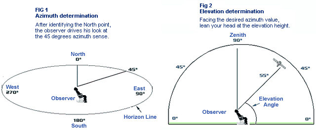
Elevation (degrees) - It is nothing more than the object satellite's height above the horizon line and like the azimuth, is measured in degrees. The values vary from zero degree, when the object is on the horizon line, up to 90 degrees, when it is exactly over our head. Therefore, a satellite that is at a 45 elevation degrees will be at half height of the horizon.
Azimuth (degrees) - Is the value measured in degrees, counted starting from the North, in the clock sense, and it indicates a point on the horizon. The azimuth values vary from zero to 360 degrees and the basic requirement to know a certain azimuth is to know where the North is. If you don't know it, the use of a compass will be necessary.

Direct Sun - It informs if the satellite is illuminated by the sun during the pass. The possible values are:
YES - The satellite is in Sunlite.
NOT - The satellite is in the darkness and eclipsed by the Earth.
SHA - The satellite is in the Earth shadow (or terminator), the line between day and night.
Height (km) - Is the measure, in kilometers, where the satellite is located above the surface..
SSP-Lat / SSP-Lon (degrees) - SSP-Lat and SSP-Lon are the geographical coordinates of the "sub-satellite point" and they indicate the point of the surface of the Earth on which the satellite orbits on that moment.
Note: If you draw a line from the satellite to the center of the earth, the point where this line intersects the earth's surface is called the subsatellite point.
Sun/EL (degrees) - Angle of elevation of the sun relative to the horizon line. Negative numbers mean that the star is below the horizon.
Contact - Possible values: Radio and Visual. It indicates the possible modes of contact with the satellite. Of course, the Visual Mode also allows the Radio contact, either through direct communication or radio-beacons.
Privacy policy |


