Debug
Waiting...
Latitude
Longitude
Distance
Period
00.00
000.00
0000 Km
0000 min
Azimuth
Elevation
Altitude
Km/h
000°
00°
0000 Km
00000.00
Local Configuration
Miami (USA)
Lat: 25.8 Lon: -80.22 Alt: 5
Timezone: UTC-3 [ Change ]
Next Pass: Day
xx
AOS: xx:xx AZ: 00°
LOS: xx:xx AZ: xx°
MAX: EL 00° / AZ 00°
Distância: xxxx Km
CONTACT:
None
Time:
Real Time Tracking
Latitude and longitude are the geographical coordinates of the "sub-satellite point" and they indicate the point of the surface of the Earth on which the satellite orbits on that moment. Distance indicates the amount, in kilometers, existing between the observer and the satellite.
Period is the time that the satellite takes to complete an orbit around the Earth, counted from perigee to perigee.
Azimuth and Elevation are the local coordinates and they inform the position on the sky where the observer should look to see the satellite or to point out his antenna.
Altitude is the measure, in kilometers, where the satellite is located above the surface. Km/h is the satellite speed inside its orbit.
Next Pass
On the up right side of this picture we have the countdown for the satellite to blunt on the horizon.
AOS - Abbreviation of Signal Acquisition. It is the moment when the satellite will appear on our horizon and its signs can already be captured. The picture indicates the hour and the azimuth of the event.
LOS - Abbreviation of Loss of Signal. It is the moment when the satellite, after passing above the place, touches the horizon line and its signs can no longer be captured. The picture indicates the hour and the azimuth of the event.
MAX and Range - Moment of the satellite's maximum approach. The numbers indicate the moment of the event, as well as the azimuth, elevation and altitude of the satellite
Contact Mode - During the passage of the satellite, depending on some conditions, it is possible to observe the satellite directly. When those conditions occur, the display will show the expression Visual. In case the satellite cannot be seen, the expression shown will be Radio Signs.
AZ-EL Scope
The visual indicator of Azimuth and Elevation stands out in the center of the screen, where we can see two concentric circles. The external line, stronger, shows the observer's horizon or station, while the internal circle, less intense, indicates a 45 degrees elevation above the horizon. The observer is located in the center of the graphic.
The outlined line indicates the path the satellite will take during its next pass. During the pass a small blinking "blip", representing the satellite, will accompany the outlined line.
The closer the blip is of the center, the higher and closer the satellite will be. Occasionally the blip can be seen out of the horizon line, since the display is able to point out over 20 degrees below the horizon.
How to Track Satellites
To track a satellite it is necessary to choose one. That is made by clicking directly on the satellite available on the "Great Visibility" column or after clicking on some of the categories. Once chosen, after a few seconds the program will begin the track the satellite.
Important
Make sure that the computer clock is correct and the time zone is compatible with your Region. On the Internet there are dozens of programs that keep your computer always on time.
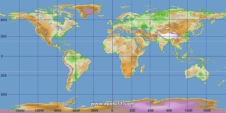
On the main screen we can see the World map, where the satellite in movement stands out by two outlined lines. These lines are called "GroundTrack". The red line shows the first 90 minutes of the current orbit and the blue line, the 90 following minutes. Each point represents the position of the satellite at each minute and gets the name of the sub-satellite Point.
On the blue screen, right the map, we have the parameters panel, updated every second, which is divided in three main areas, as shown below.
Visibility conditions
For a satellite can be observed directly, it is necessary that the sunshine reaches its structure and is reflected into our eyes. For that to take place, it is necessary that the following factors are present at the same time:
1 - Dark sky: it should be night on the observation location
2 - The Sun's height: the solar disk should be between 10 and 25 degrees below the line of the horizon
3 - Illuminated satellite: the sun rays should be reaching the satellite directly
4 - The elevation angle: the satellite should be at least 25 degrees above the horizon
When these four conditions are achieved, we say that the satellite will be potentially visible during its passage over our station. Meaning that technically, it can be seen, nevertheless other factors can influence its observation, among them the satellite's altitude and size, its coating material and the atmospheric conditions of the local observation.
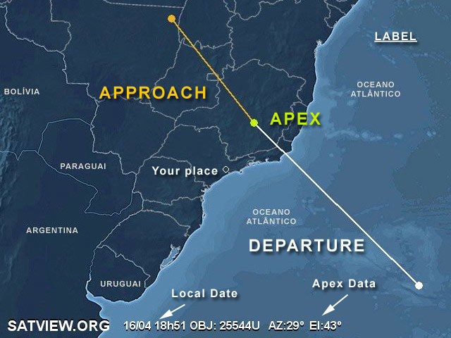
As a general rule, the closer the satellite passes over our station, the better the observation will be. That closer approach is directly related to the height of the satellite above the horizon line. The angle formed between the satellite and this line is called the elevation angle and the bigger this angle is, the closer to us the satellite will be.
The apex of that approach takes place when the satellite is exactly over the zenith, in other words, 90 degrees above the horizon, but not all the passages effectively reach that position.
Orbital Elements: 25 Apr 2024 05:01 (2024 116.20933586)
STARLINK-1180
1 45076U 20006AJ 24116.20933586 .00024475 00000-0 20622-3 0 9997
2 45076 53.0544 82.1577 0001349 70.8619 289.2543 15.69714470234245
BD Usado: master_uss
Launch.: 2020 (6° from year, payload A)
Period: 91.7 min.
Revs/day: 15.7
Incl.: 53.1 degrees
Apogee: 358 km
Perigee: 358 km
Semi-major axis: 6736 km
|
|